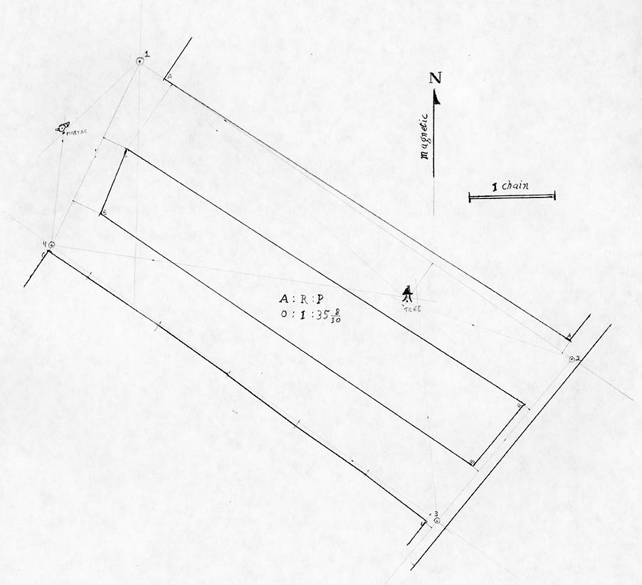
This was the first field trial of my surveying gear. Kevin and I went to Saratoga Battlefield National Park and surveyed the field immediately outside of the visitors' center. This field drops down a hill and was divided into two mown areas separated by an area of brush or furze. On either side was more brush. At the edge of the field near the visitors' center was a grassy flat spot with a mortar, benches, and other items. At the far end of the field is a grassy road.
We used an old USGS marker as our point of beginning and ran four survey stations spaced in a rough rectangle around the field, measuring to the corners of the brush areas. We also measured to a lone tree in one of the mown areas, and took sights to the mortar on the lawn.
Very quickly we discovered how well the surveying equipment worked. The chain frequently caught on stubble in the field, which would pry open the eyes of the links and the rings between the links and split the chain in two. After measuring the first two chain lengths with various failures, we adopted the technique of picking up the chain in loops to move it along the survey. Dragging simply didn't work. Afterwards, the chain worked just fine, but it was less convenient than expected. Also, we learned not to set the chain down casually or it would get tangled.
The compass is hard to read due to reflective glass and the lack of tripod. Placing it on a staff helped, except then it was too high to read easily. Ideally, I should make a 4 foot staff for the compass.
All of the other gear worked well. This included the station staves, the offset staves, the chaining pins, and the surveyor's cross.
I recorded the survey in the field book. I made an eye draught (a rough sketch) of the survey on one page, then recorded all of the observations on three other pages. I may scan in the field book at a later time.
For most of the survey, we only measured to the corner of a region. Along the line between stations 3 and 4, we measured offsets to the brush at every chain length. This shows up as a mildly wandering line on the southwest side of the map.
I drew up a map of the survey using a ruler and protractor. I used a scale of 60 links to 1 inch (475.2 to 1), mainly because I own a ruler with this scale and it would fit on a sheet of 14 x 17 inch paper. A copy of the map is shown below.
I averaged the foresights and backsights between each pair of survey stations. Using the averaged angle, I started at the POB (marked 1 on the map), and drew the line to station 2, marking the observed features along the way. From this, I draw the line to station 3, and then to station 4. Upon drawing the line from station 4 back to the station 1, I found that the survey was around 1 degree and 3 links from closing perfectly. Not bad considering how rough it seemed in the field.
The lone tree was measured using five observations: an offset from the line between stations 1 and 2, plus four angles from each of the four stations. These observations did not converge that well; three of the angles and the offset were within 10 links of a spot; the remaining angle went wide.
Two other points were over constrained, the southrnmost corner of the field and the northernmost corner of the central furze area. Both of these matched within a link of so. Since the second of these involved some long offsets, it shows that the survey wasn't terribly inaccurate.
I inked the boundaries on the map, plus added a north arrow and a scale. I also calculated the area of the central furze area, which was 0 acres, 1 rood, and 35.8 poles. As a rood is 1/4 acre, and a pole is 1/40 of a rood, this is the same as 0.4737 acres.
The map was scanned at 72 dpi.
[ Historical Surveying | Manthey Central | Orbital Central | Site Map ]